


Newtown area on Red Alert as Storm Dennis strikes

Emergency workers have been stretched overnight as Newtown was put on red alert for flooding.
Local rivers, including the River Severn, burst their banks with many of those working through the night saying it’s as bad as they have seen.
The Newtown area is particularly badly hit with the culvert on Dolfor Road failing to cope (picture by Joy Jones) with the volume of water and the Newtown-Welshpool road closed at Coedydinas, near Welshpool.

Minor roads are closed and emergency services are warning people to stay at home and avoid travel wherever possible.
Daley Jones was travelling to a job in Newtown from Welshpool shortly before the local 1am red alerts were issued and he posted: “On the way to a job and the roads are heavily flooded and debris everywhere. Worst I've seen.”
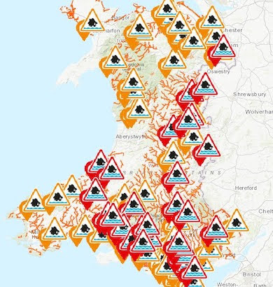
The advice is to stay home and avoid any unnecessary journeys, with the following red alerts issued by 1am but being updated regularly.
But the forecast is not great for the next 24 hours with more rain and winds expected, before it eases off through the night and into Monday.
The best sources to follow are (but they are facing heavy traffic at the moment):
https://naturalresources.wales/flooding/check-flood-warnings/?lang=en
RED ALERT
Lledan Brook in Welshpool
At 1:00 AM, the level at Lledan Brook was 0.8 metres and rising. A peak level of between 1.0 and 1.3 metres is expected to occur this morning. The following roads could be affected by flooding; The A49 Church Street, and the B4 381 Brook Street, Welshpool.
RED ALERT
River Vyrnwy in the Meifod area
At 11:30 PM, the level at Meifod was 3.1 metres and rising. A peak level of between 3.4 and 3.8 metres is expected to occur tomorrow. The following roads could be affected by flooding; The A495 at Newbridge, near Meifod.
RED ALERT
River Vyrnwy at Llanymynech
At 11:30 PM, the level at Llanymynech was 4.16 metres and rising. A peak level of between 4.6 and 5.3 metres is expected to occur tomorrow. The following roads could be affected by flooding; The B4398 near the canal at Newbridge, Llanymynech. The A483 between Llanymynech and Four Crosses, just south of Llanymynech Bridge.
RED ALERT
River Severn at Abermule and Fron
At 12:15 AM, the level at Abermule was 3.13 metres and rising. A peak level of between 3.5 and 4.5 metres is expected to occur this afternoon. The following roads could be affected by flooding; Some minor roads in the Abermule area. The A483 at Fron.
RED ALERT
River Severn at Caerhowel
At 1:50 AM, the level at Abermule was 3.83 metres and rising. A peak level of between 3.9 and 4.2 metres is expected to occur this morning.
RED ALERT
River Severn at Dolwen and Llandinam
At 12:45 AM, the level at Caersws was 2.8 metres and rising. A peak level of between 3.1 and 3.5 metres is expected to occur this morning. The following roads could be affected by flooding; Manthrig Lane in Caersws. The A489 trunk road at Long Length, Caersws.
RED ALERT
River Severn at Aberbechan
At 12:15AM, the level at Abermule was 3.13 metres and rising. A peak level of between 3.5 and 4.5 metres is expected to occur this afternoon. The following roads could be affected by flooding The B4 389 at Aberbechan.
RED ALERT
River Severn at Trehelig
At 2:00AM, the level at Munlyn was 3.28 metres and rising. The following roads could be affected by flooding; The A490 at Cilcewydd and the Trehelig Crossroads. The A483 between Wernllwyd & Sarn-y-bryn-caled and the B4 381 at Lower Leighton.
RED ALERT
River Vyrnwy at Melverley
River levels are rising at the Llanymynech and Crew Green river gauges as a result of Storm Dennis. Consequently, flooding of property, roads and farmland is expected to begin from 3am, Sunday 16/02/20. Flooding is affecting properties and roads in and around Melverley including acre lane, Melverley to Melverley Green and Ponthen to Melverley roads including the A483 between Llanymynech and Four Crosses, just south of Llanymynech Bridge. Predicted peaks:- Llanymynech 4.6 to 4.8m Sunday lunchtime, 16/02/20, Crew Green 6.1 to 6.4m Monday morning, 17/02/20. Further heavy rainfall is forecast over the next 12 hours. We expect river levels to remain high for the next few days. We are closely monitoring the situation. Please avoid contact with flood water. This message will be updated by 9am on 16/02/20, or as the situation changes.

Local rivers, including the River Severn, burst their banks with many of those working through the night saying it’s as bad as they have seen.
Lledan Brook, in town, is expected to reach levels of 1.3m this morning with flood damage likely to property and warnings of flooding to Church Street and Brook Street.
The roads to Llanfair Caereinion, Forden, Arddleen and Newtown are all impacted and the usual trouble spots like Llandrinio Bridge under several feet of water (pictures).
Daley Jones was travelling to a job in Newtown shortly before the local 1am red alerts were issued and he posted: “On the way to a job and the roads are heavily flooded and debris everywhere. Worst I've seen.”
The advice is to stay home and avoid any unnecessary journeys, with the following red alerts issued by 1am but being updated regularly.
But the forecast is not great for the next 24 hours with more rain and winds expected, before it eases off through the night and into Monday.
The best sources to follow are (but they are facing heavy traffic at the moment):
https://naturalresources.wales/flooding/check-flood-warnings/?lang=en
RED ALERT
Lledan Brook in Welshpool
At 1:00 AM, the level at Lledan Brook was 0.8 metres and rising. A peak level of between 1.0 and 1.3 metres is expected to occur this morning. The following roads could be affected by flooding; The A49 Church Street, and the B4 381 Brook Street, Welshpool.
RED ALERT
River Vyrnwy in the Meifod area
At 11:30 PM, the level at Meifod was 3.1 metres and rising. A peak level of between 3.4 and 3.8 metres is expected to occur tomorrow. The following roads could be affected by flooding; The A495 at Newbridge, near Meifod.
RED ALERT
River Vyrnwy at Llanymynech
At 11:30 PM, the level at Llanymynech was 4.16 metres and rising. A peak level of between 4.6 and 5.3 metres is expected to occur tomorrow. The following roads could be affected by flooding; The B4398 near the canal at Newbridge, Llanymynech. The A483 between Llanymynech and Four Crosses, just south of Llanymynech Bridge.
RED ALERT
River Severn at Abermule and Fron
At 12:15 AM, the level at Abermule was 3.13 metres and rising. A peak level of between 3.5 and 4.5 metres is expected to occur this afternoon. The following roads could be affected by flooding; Some minor roads in the Abermule area. The A483 at Fron.
RED ALERT
River Severn at Caerhowel
At 1:50 AM, the level at Abermule was 3.83 metres and rising. A peak level of between 3.9 and 4.2 metres is expected to occur this morning.
RED ALERT
River Severn at Dolwen and Llandinam
At 12:45 AM, the level at Caersws was 2.8 metres and rising. A peak level of between 3.1 and 3.5 metres is expected to occur this morning. The following roads could be affected by flooding; Manthrig Lane in Caersws. The A489 trunk road at Long Length, Caersws.
RED ALERT
River Severn at Aberbechan
At 12:15AM, the level at Abermule was 3.13 metres and rising. A peak level of between 3.5 and 4.5 metres is expected to occur this afternoon. The following roads could be affected by flooding The B4 389 at Aberbechan.
RED ALERT
River Severn at Trehelig
At 2:00AM, the level at Munlyn was 3.28 metres and rising. The following roads could be affected by flooding; The A490 at Cilcewydd and the Trehelig Crossroads. The A483 between Wernllwyd & Sarn-y-bryn-caled and the B4 381 at Lower Leighton.
RED ALERT
River Vyrnwy at Melverley
River levels are rising at the Llanymynech and Crew Green river gauges as a result of Storm Dennis. Consequently, flooding of property, roads and farmland is expected to begin from 3am, Sunday 16/02/20. Flooding is affecting properties and roads in and around Melverley including acre lane, Melverley to Melverley Green and Ponthen to Melverley roads including the A483 between Llanymynech and Four Crosses, just south of Llanymynech Bridge. Predicted peaks:- Llanymynech 4.6 to 4.8m Sunday lunchtime, 16/02/20, Crew Green 6.1 to 6.4m Monday morning, 17/02/20. Further heavy rainfall is forecast over the next 12 hours. We expect river levels to remain high for the next few days. We are closely monitoring the situation. Please avoid contact with flood water. This message will be updated by 9am on 16/02/20, or as the situation changes.


|

|

|

|

|

|

|
|
|

|

|